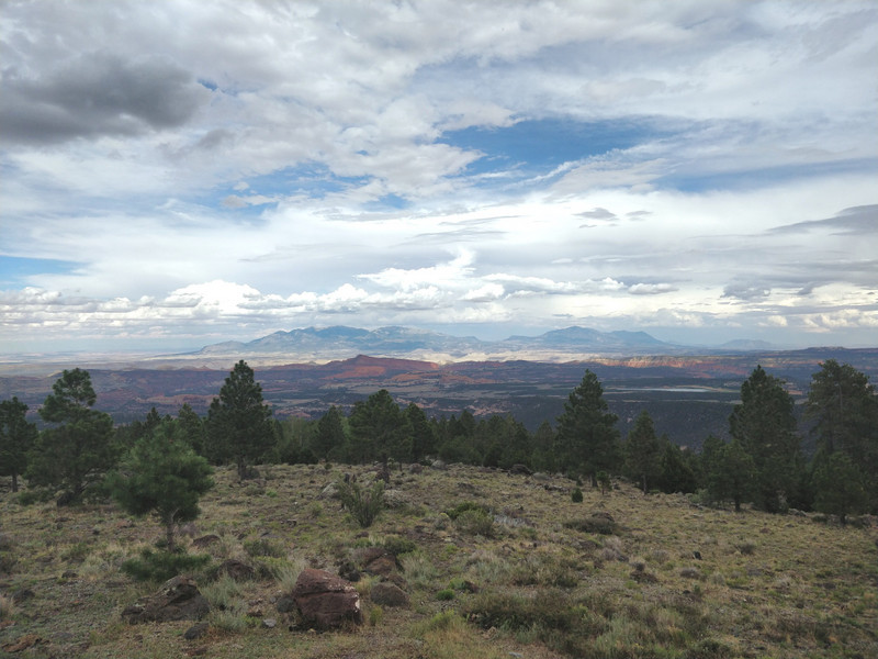
Fantastic view towards east from the pass at the altitude of around 2700m. n.p.m. The visible red line is the Capitol Reef, while the mountains in the background are the ones around Mt. Ellen. This picture was taken on 15 July 2018 during my previous trip to the area.
One of the largest protected areas in the USA, Grand National Monument, extends along the southern border between Utah and Arizona. Similarly to national parks, national monuments are owned by the federal government, but the protection level is lower. I dont know what exactly is protected and how but, for example, the rules for camping are much more lenient than in national parks. While the details depend on a monument as well as specific areas, the general rule is that camping is allowed in more remote parts of the park. It is always good to check the monuments website for the rules and if the permit is required.
Grand National Monument was created in 1996 by President Clinton and it immediately became an object of political contention. It was argued that the protected area of over 7500 square kilometers is simply too large and the monument was created without consultations with the locals. In 2017 President Trump reduced its size by almost half and the current (as of April 2021) area equals about 4000 km^2.
View towards east from the road between Boulder and Escalante. The same Capitol Reef and mountains as in the previous picture. This time the snow present in late May is visible.
The lowest part of the park stretches along the Colorado River serving as its southern boundary. At the elevation of about 1000m the landscape is dominated by deserts and steppes, with curvy canyons and cliffs. In the northern part, however, mountains 3000m high can hold snow all year round. I must stress that due to its immense size I have seen only a very small part of the monument. It is worth adding that Grand is not a major tourist destination despite the breathtaking views. It may be due to the fact that the tourists simply do not know too much (yet) about what it offers and choose the bordering national parks of Capitol Reef and Bryce Canyon instead.
First and foremost, when entering or leaving Grand one simply must drive route from Hanksville to Torrey and then via Boulder to Escalante. This is one of the most fantastic routes I have ever traveled. While we leave Hanksville in short sleeves and in 30+ degrees heat, we should not forget a jacket and gloves. After one hour drive we find ourselves among snow patches on a pass with the elevation of 2700m. But the elevation
A dirt road towards the Colorado River and the Reflection Canyon. The cliff on the right is the bench. (photo by Łukasz)
gain is not the whole story. During the drive we cross almost all climate zones and landscapes: from sandy deserts to Alpine forests. The first part of the route, from Hanksville to Torrey, can be seen