With only one bus connection, getting to Torla from Huesca was pretty easy without a car. Getting out will take some creativity, luck, or money.
The scenery was pleasant and the road - which is only mostly finished - is a architectural wonder in itself, winding along ravines and through sheer rock cliffs, all with the luxury of guardrails.
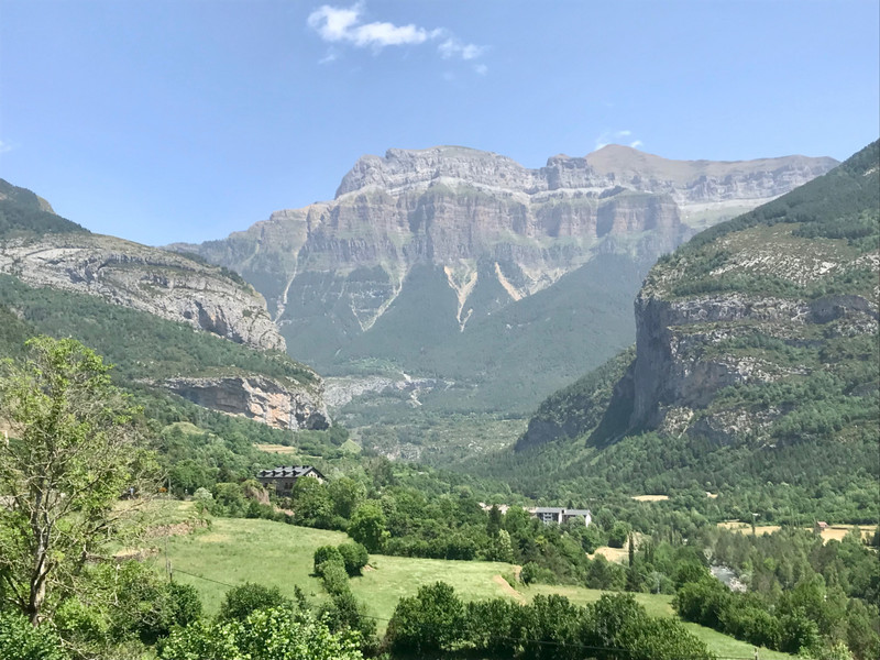
Torla is a Spanish town. Its charm, remoteness and proximity to Parque Nacional Ordesa y Monte Perdido, make the expensive.
I had to make reservations ahead of time since it was the start of the high season and because of the illusion that if you cant find a place online, it must not exist. Judging from the average age of the tourists here, I should have just shown up at the Albergue (youth hostel) and made my case. Instead, I had to deal with a place who wouldnt let me in to leave my bag, though their neighbors were nicer and helped me out. Nevertheless, I got my private room for under $50 a night, albeit with no wifi and with a steady stream of minimalist French backpackers talking loudly in the mornings. At least hikers
Id read that during the summer, national park visitors have to take a bus into the park to limit the crowds, but I guess June 19th is not technically summer yet. This actually worked out well since for the carless, theres a nice, trail from town and into the park along the river, which adds a couple of silent hours / about 9k each way to the trek.
The trail begins at Hotel Bellavista, crosses Rio Arazas and rises slowly into the ‘Pradera on the eastern side of the river, the cliffs providing shade from the morning sun. The signage isnt bad but the names dont correspond well with the map and some have more than one name since they overlap with the GR11 and GR15. The trail splits and you can take Turieto Alto instead, but Turieto Bajo was already high enough for me. A short excursion to the turquoise natural pools near Puente de los Navarros is a perfect place for a rest or a swim in the turquoise water. Once past the bridge you enter a pine forest, with some sections so smooth you could probably walk barefoot.
There are a few powerful cascades with viewpoints along the way. But waterfalls rarely make for good photos.
There were hardly any other hikers on the trails but on my way back I found a phone that had obviously been dropped recently. The owner was Polish and Id recently passed a couple who might have been Polish so I ran the mile back to the parking lot but ended up giving the phone to park rangers. By the time I got back to the spot, a woman was there frantically searching for her phone. She was happy to hear Id found it but I probably should have just left it. I saw her and her husband at the pizza restaurant in town and they either didnt recognize me or were annoyed by my ‘help.
Its hard to tell where this trail begins but once you arrive near the parking area, it fairly obvious that you need to cross a bridge to get to the Cola de Caballo trail. If you can handle heights and sheer drops (I cannot), continuing on Senda de Cazadores will take you to Faja Pelay, which rises to the belt
above the first cliff and which undoubtedly has very few hikers. It also ends at the Cola de Caballo waterfall.
The trail is technically called Ruta Pradera and is one of the most crowded trails Ive ever been on, especially considering the remoteness of the area. Its as wide as an American rail trail in most sections and not very difficult. The result is plenty of families, dogs, and even massive school groups. I should probably just be impressed to be in a country where so many can hike 20k.
A woman I spoke to on the trail said its much worse in July and August, which is difficult to believe. I cant imagine any 20k hike in a US national park being that busy. We just have so much more space.
I had planned to continue on 3km more to Refugio Griz but the trail was steep, so I turned around to do the same 4 hours in the opposite direction.