Im excited, finally getting to visit the worlds largest island with the least densely populated region on earth. Hard to believe only approximately 56,000 warm bodies live on a hunk of rock 3 times the size of Texas! The majority of its residents are Inuit, whose ancestors migrated from Alaska through northern Canada, gradually settling across the island by the 13thcentury. Most reside along the southwest coast, the area Ill be exploring.
According to Icelandic Sagas Erik the Red, who had been banished from Iceland allegedly for manslaughter, settled what is now Greenland in 982. Upon returning to Iceland around 985, he praised the merits of this newly discovered land and by 986, he had organized an expedition which resulted in the development of Nuuk and Qarqortoq. Greenland became Danish territory in 1814 and in 1979 was granted home rule, giving local government far more power – however the Danish government still retains control of citizenship, monetary policy, and foreign affairs, including defense.
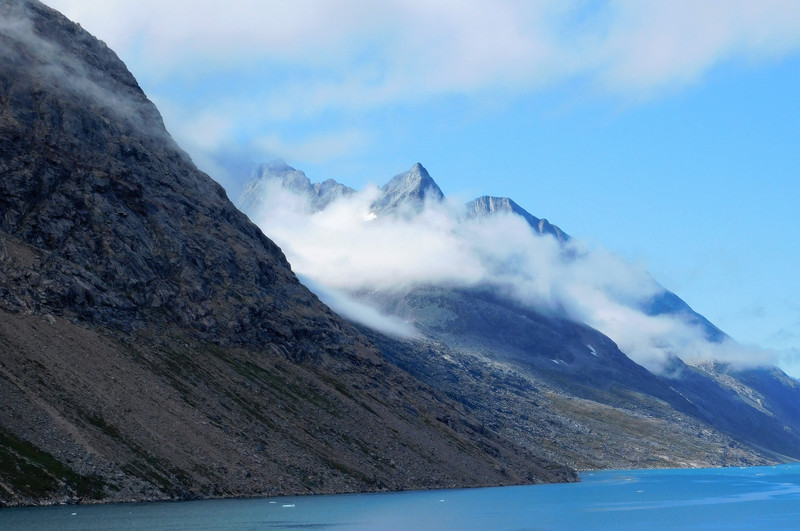
Sailing west, we approached our destination by entering Prince Christian Sound – a relatively narrow waterway separating mainland Greenland and islands in the Cape Farewell Archipelago. Its named in
honor of the prince (later king) Christian VIII of Denmark and is considered Greenlands most scenic inland passage. Approximately 66 miles long, it occasionally narrows to 1,600 in many places, and has only one settlement (Aappilattoq, an Inuit town with about 100 residents) along the Sound. Adventurer John Cabot described this as a river of melted snow. This incredible fjord system is mainly surrounded by steep mountains most of the peaks reaching over 3,900 and one tops out at 7,280. A number of glaciers grace the mountain crevices and go straight into the waters where they calve icebergs on a frequent basis. Hundreds of icebergs of every shape and size were present as we made our way through this magical waterway. Strong tidal currents limit the formation of ice, but its accessible only by ship during summer months, when warmer temperatures reduce the chance of ice blockages around the entrance. Its a dangerous place for ships to transit and it requires very slow speeds to avoid these floating monsters – do we have fifty shades of the Titanic here? Weather couldnt have been more fantastic with brilliant sunshine, cloudless blue skies, temps hovering around the low 50s and stunning vistas
Nanortalik - my first sight of mainland Greenland is arrival in Nanortalik (means place of polar bears), the 11th largest city in the nation (who knew they even had that many?), with a population around 1,300 – and so Im told – fueled on fresh air, strong coffee, and diverse personalities. Sighting the town would be an exaggeration – the entire region was socked in with dense fog – impossible to see further than 10 ahead. This barrier to disembarkation continued until after lunchtime, when the captain decided to cancel this port of call stating that logistics of transferring almost 2,000 passengers ashore via tender, would be virtually impossible with less than 5 hours of land time left. The afternoon proved to be as fabulous weatherwise as yesterday had been, but it was simply too little too late – we were already sailing on to the next Greenland port of call.
Because of its location, this area was one of the first parts of Greenland settled by the Vikings and one of the last settled by the Inuit. The town was founded in 1770 as
Nennortalik and in 1797, a permanent trading depot was set up in Nanortalik by traders from Julianehab. Due to poor harbor facilities, the town was moved three miles northward in 1830, where it remains today. Of the old town, only some scattered ruins remain.
Tourists are very here as Nanortalik has little productive trade. There are no factories and no fishing activities, as sea ice prevents fishing for several months a year.