It was raining from the start of the ride today, so it was wet gear from the Some heavy rain & occasionally some less heavy. 20 miles on seal and then into the forest as usual. We climbed & climbed & then climbed a bit more, reaching around 3500 feet. On this road we met and spoke to a hunter in a 4wd. He said he was hunting hogs & bars (bears). He was following his dog by satellite tracker and he thought it was onto something in the bush, probably a hog
We did 2 stream crossings early in the day without incident. Ian has just pointed out that we have just clicked over 4000kms on this trip so far. We are now into the Great Smokey Mountains – so looking for a banjo shop! Our route took us up & down to over 3000 feet at least 4 times (at altitude the rain was by mist) on quite good roads before descending again. Sometime during this part of the track we came to a bridge over a stream which was made of flat steel plate. That was fine except it was on
a corner! We all made it across successfully even though it was raining and there was a layer of water on the steel.
We came to part of route where there was a one way sign and unfortunately it was not the way we were going. This was a very narrow track which almost looked so we investigated for a couple of miles before deciding discretion was the better part of valour and returned the way we By this time we had reached around 4850 altitude and although the ambient temperature was reading 15 degrees we all felt a bit cold. Donning a few extra layers a large loop to connect back to the TAT. We stopped for gas & lunch. While we were outside eating our hotdogs, Keith spoke to an Indian – probably a Cherokee as this was a Cherokee reservation with a lot of very smart Keith asked him if he could do something about the temperature, He said he will go home, light a fire and sing a song for us. Well it worked as around 2.30pm it stopped raining and warmed up. We arrived into our destination
We struggled for a bit to find before a guy in the Information Centre told us to try the backpackers. This town is on the Appalachian Trail and is a stepping off point for a lot of hikers. The Trail starts in Georgia and goes all the way to Maine. We looked all around town but Bill Bryson wasnt here.
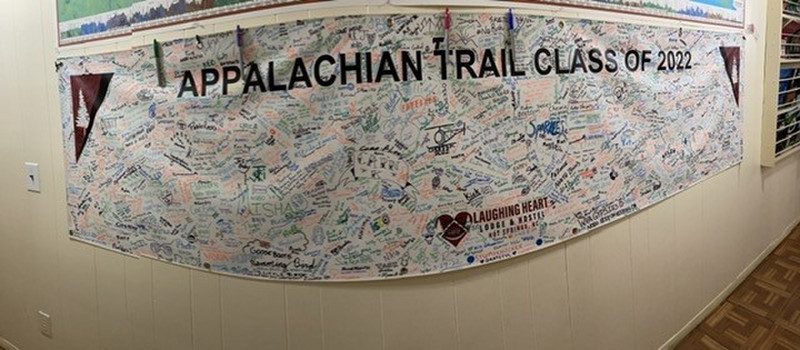
The backpackers hostel catered mainly to hikers and you can see from the photo of their wall chart how many have stayed so far this season. Keith met a guy who plans to walk the trail next year in 100 days. Its 2100 miles long so if he succeeds will be a great effort. He says he will go through 4 pairs of shoes and is looking for a shoe manufacturer sponsor! A Lady working here has walked 1000 miles from Washington DC to Florida. Theyre all walking mad!
de (I think the owner with a cowboy fetish) packing a pistol. See the photo. Keith asked him why do you carry a gun? His reply was I dont take no sh*t from This begs the question (which we were too nervous to ask) what came first? The sh*t or the gun?
The Backpackers (Laughing Heart) was a good place to stay. They didnt have linen so I unpacked my new emergency sleeping bag. It was like a giant potato chip bag, foil on the inside & plastic on the out. In fact I am sure it smelled like salt & vinegar. Anyway due to its thermodynamics, I must have got quite hot during the night and thrashed about & it ripped apart like you would expect a chip bag to do. No more backpackers unless I can buy a better quality lightweight sleeping bag.