When planning this trip, there were two key places I wanted to visit and everything else was added while joining the dots. The first is the Flinders Ranges, which will be the final stage of my visit to South Australia. The other was Googs Track.
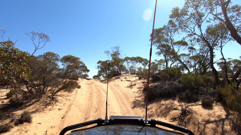
Googs Track runs north from Ceduna up to the railway through remote country. Described as a Desert, it crosses approximately 360 sand dunes as it passes the salt lake named after the first white man to set foot on it, Googs Lake, and Mount Finke. While it is not a long distance - the track itself goes for about 150km – you need to be as the distance between services is about 350km and there is essentially no water along the way.
On Friday morning I stopped for a quick supply at the supermarket in Ceduna and after marvelling at the price difference for my favourite loaf of bread (its easy to forget how much transport costs for our groceries) I was ready to go. While filling up on fuel I had a chat with a truck driver from Western Australia who had done the track and while his advice was
The road north soon turned to gravel as I passed the last few farms before the Yumbarra Conservation Park. The last farm, Lone Oak, is owned by the Denton family. John Denton (known as ‘Goog) and his son Martin (‘Dinger) cleared the track north during the 70s. It was here that I aired down, reducing my tyre pressure to 16 psi because of the sand ahead. There was no shortage of flies to help me, so I was glad Id picked up a fly net.
I passed through the two gates, one being the dog, or dingo, fence that crosses the country from the Nullarbor to southern Queensland to protect the of Australia from dingos. The first part of the drive was easy, but I took it slow as I had all day to get to my first campsite at Googs Lake. Even when I encountered the first sand dunes, my Hilux just ate up the track and I thought it might get a bit boring if it remained like this.
in my book simply as To Rockhole. I had plenty of time so I decided to check it out. A couple of kilometres later I parked the car near a fenced off area with a sign saying it was an area of indigenous cultural significance. I walked a short distance to a large section of rock which, unsurprisingly, had a hole in the middle. There was water in the hole, and it was obvious why this was important to the original inhabitants of the area because they would have needed places such as this to survive in such arid country.
I returned to the main track and continued on. The first section of the track was straightforward, but I still enjoyed it. Before I knew it, I was nearly at the Denton Family Memorial and Googs Lake. As it was only 1pm, I decided to check out another this one marked To Old Airstrip.
I never found the airstrip, but I drove along about 10km before my GPS said there was no more road. I found this difficult to believe because I could quite clearly see the road ahead of me. I kept driving, feeling like an
Getting out of the car, I walked across the lake to take some photos. Underneath the salt was a layer of mud, so I was glad I was not stupid enough to drive on it. I wasnt the only one to have walked on it as I encountered a few sets of emu footprints. However, being a desert, there was a lack of grass to wipe the mud off my boots, so I decided to wait for it to dry by having some lunch. With a full stomach and slightly cleaner shoes, I continued on the track.
I came to an intersection and randomly took the turn. I soon came to a much larger salt lake that turned out to be Googs Lake. There were a lot of good campsites and I found one at the end of the track that was only 5 metres from the lake shore. I realised these were the camp sites on the south shore of the lake that one of my books mentioned and decided I would explore the other track back
The other track continued around the southern end of the lake for a bit, gradually more overgrown until eventually it stopped altogether.
