Touted as one of the most aggressive of the Backcountry motorcycle routes, the start is designed to test your skills. For the first five miles, one is faced with a damp track edged into the forested hills above the Delaware. The route involves climbing rock strewn inclines and dodging along trails strewn with stones, with one side sloping 200 feet down to the river. Very picturesque, but woe betide anyone who looks at the scenery for more than an instant. Total concentration is needed to get through this lot. After about 10 miles of similar track, it eases up. The route crosses the river 20 miles later at Callicoon, and doubles back a few miles. There were many opportunities for that perfect river side photo. In the sweat to survive, Im not sure I got it.
The route turns North, skirting ponds, lakes, reservoirs, all of them part of the East Branch of the Delaware catchment. Not sure if it was the effect of Covid or that it was Thursday, but I had the forest to myself. A majestic young buck with small antlers, waiting for me in the clearing. A large raptor (hawk or eagle) brown with white
I was found here by the NYPD. I pleaded to guilty to eating and while absorbing the scenery. The officer was sympathetic.
flecks watched me go by underneath. Flocks of wild turkeys ran for cover as I approached. It is an idyllic area. I discovered to my surprise that it is a park, owned and protected by New York City as a water source. They do a good job. I was happily eating my sandwich in the sun by a small pond, when I was approached by one of New Yorks finest in a big black SUV who wanted to know where I was from and why I was sitting by myself in the woods. Hed never heard of my motorcycle route. We parted friends. The roads were a delight. After the initial stress test along the river, they became rambling gravel with the occasional sand or mud. Forest the whole way. The maples just starting to turn. The weather warm and sunny. Completed the 142 mile run to Margaretville by late afternoon and found my motel. Thanks to Covid, the motels are managed with no human interaction. My key and receipts were left stuck to the office window. I found my envelope, let myself into my room, and found peace.
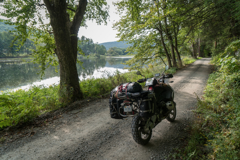
There were covered bridges all along the route. Most had been restored, and were used as crossings or formed the basis for a park. I never knew they were so revered.
bike is designed like a fuel camel, with huge hump up front that carries 8 gallons, enough for 320 miles. Sounds like all I needed to do was keep it full and I need never fear running dry. So I filled it up. However, all that fuel is very heavy. With the tank full, and all my kit on the back, the motorcycle on anything but paved roads. That morning I feared for my ability to keep in upright in the stone and mud sections I was expecting to find along the way. So I bought a hosepipe and drained a bunch of fuel from the full tank, so that I the bike could be tracked more easily. Sounds good. Except, that the fuel tank gauge is extremely inaccurate. It shows sorta full and sorta empty. But the accuracy between these extremes is very hazy. So I was guessing, by sloshing the bike around and listening to the tank and doing dead reckoning on how far I had gone and how much fuel I had used. Not all that exact. I did get a NO FUEL warning light, which the German engineers have built into the bike once
you get into the last gallon. Luckily I found a general store not so fare away that sold me some regular. And I was able to guide the bike along without falling for 1,300 miles, so I guess we found our measure, the bike and I.