Leaving the campsite at Cope Hut the following morning, I soon found myself walking along a vehicle track alongside the beautiful, clear waters of the Langford West with a healthy population of small freshwater fish. A short detour up a then brought me to the oldest surviving cattlemans hut in the High Country: the Wallace Hut, built in 1889 by three brothers from the Wallace family, who were thus able to spend weeks at a time driving cattle across the High Country pastures whilst living in in their shelter.
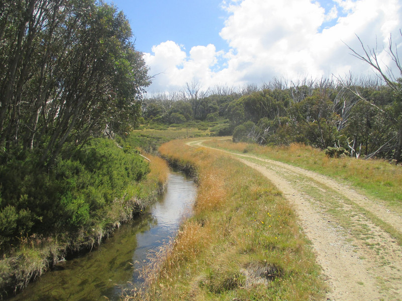
Back on the main track I followed the gentle curves of the aqueduct as it pursued its course high up on a ridge that wraps around the head of the Middle Creek valley. Not only was the walking easy, it was truly delightful. of nice weather, flat terrain, a firm dry surface to walk on, expansive views down over the eastern edge of the High Plains towards the pastureland beyond, and the flow of the stream beside me conspired to instill in me a feeling of pure tranquility. While I had expected this day to provide my
easiest walking of the week - due to the lack of significant climbing and overall distance - I hadnt expected it to be so damn pretty!
So the disappointment was palpable when suddenly the stream disappeared just as quickly as it had first appeared, vanishing underground into a buried pipeline that feeds the Rocky Valley Storage - a reservoir near the alpine resort of Falls Creek. Consoling myself with lunch inside but quaint Langfords Gap Hut, I was then pleased to find after lunch that the continuing track now ran alongside the Langford East Aqueduct, providing me with another hour of serene walking before eventually my route along both the Falls to Hotham Alpine Crossing and Australian Alps Walking Track crossed the water on a lovely little covered footbridge and proceeded to climb up and over the shoulder of a thickly forested hill.
Coming out onto another section of the Bogong High Plains - only this time noticeably firmer underfoot than the previous day - I eventually joined another vehicle track before farewelling the Falls to Hotham route at the junction for Heathy Spur. Slowly winding its way up and around the rounded bulk of
Mount Nelse, the track brought subtle changes in scenery, with the peaks of Mount Buffalo and Mount Feathertop both outlined against the sky - though disorientingly it felt as though many of the surrounding peaks were higher than me, when I knew this not to be the case. Only when I stopped off to scramble to the top of Mount Nelse North (which at 1884m is the mountain in Victoria) did this feeling dissipate, as it quickly became apparent that all but two of the visible peaks were in fact lower than where I stood. It was also from the top of Mount Nelse North that I finally got my first good look at the highest - and by far the biggest and bulkiest - mountain of them all, Mount Bogong. To say this behemoth of a mountain was impressive would be a serious understatement, and I had my sights firmly locked on its imposing features for the remainder of my days walk.
And then, when I thought the day couldnt possibly get any better, it did just that. Arriving at Roper Hut to find the most delightful campground liberally scattered with sublime snow gum trees, I then
took a look inside the hut and instantly abandoned any thoughts of setting up my tent. Built to replace a much older hut that burnt down (along with many others) in the bushfires of 2003, the new Ropers Hut was everything you would want a bushwalkers and skiers refuge to be: clean and easy on the eye. It also had character, and a lovely (if subtle) timber scent that spoke of its youth. A better place to spend a night high up in the mountains I could not possibly think of - and I had the place all to myself....