We woke up pretty early at around 5:30, and I finally forced myself out of bed by 6. Meanwhile, my sweet wife had gone to the nearby gas station to get us some fresh coffee. When Id gone to bed, I felt except for my My Pillow travel pillow which was a bit too small for use in the bed. Sometime a bit later, I got so cold that I had major chills and shakes, waking up my wife. I put on extra clothes and my wife shared her little blanket, and I finally settled down enough to fall back to sleep. Tomorrow we will buy another pillow for me, and Ill dress a bit warmer after this.
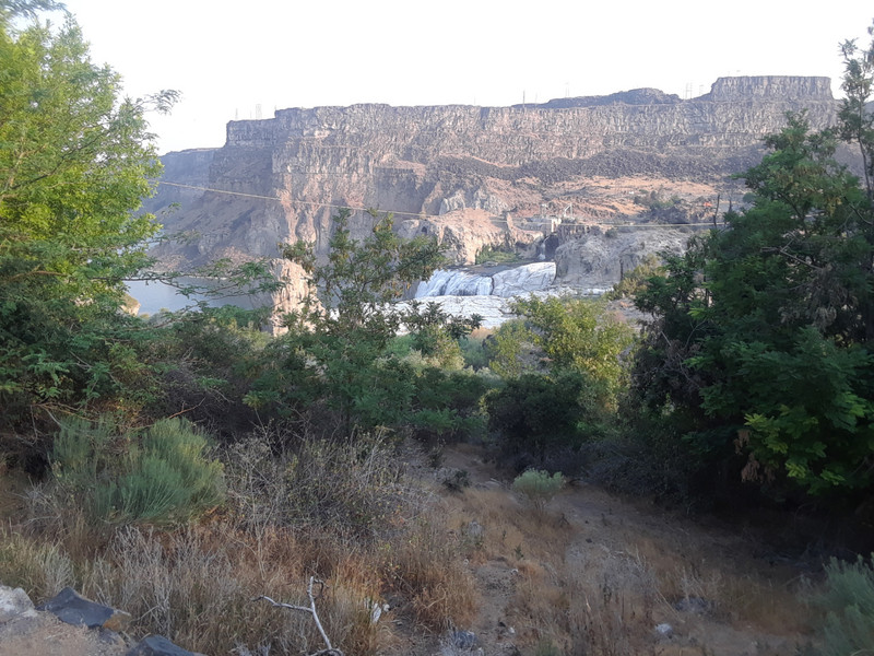
After getting dressed and finishing off our coffees, we were on our way to our first stop, Shoshone Falls, just a little past 7am. I forgot to mention that our Hyundai Elantra rental car had a nice feature where you plug in your phone and display Google Map directions, and it will display the map and play the audio while you drive! Nice feature. It turned that there was a plus to getting to the Shoshone Falls Park so early...
they were open, but not manning the entrance booth. We figured wed pay the $5 entry fee on the way out, but when I mentioned it to a park range we met, he told us no problem.. one of the benefits of being early. The falls were awesome! They are hard to describe, so check out the photos. There are a couple of good overlooks, plus a short path along one side with some good viewpoints too. The ranger we talked to told us that we were also lucky that they had already turned on the water. Apparently, most of the waterfalls are caused by opening the dam, which where closed at night or some such. We took a lot of photos, and met our first native creature, the rockchuck. He looks a lot like, and is related to, the woodchuck. They are often hunted by farmers to keep them from eating their crops. The one we saw was almost posing for us at the top of a rocky outcrop. Check out the photo and inset.
We left the park and headed for our next stop, Perrine Bridge. The directions the phone provided either werent good, or I didnt
follow them correctly. We ended up going back across the bridge to turn around back. We found a little turn off parking area and after a short walk down a nice viewpoint from below the bridge. This bridge is quite cool, spanning the Snake River Canyon way below. After a number of photos, we continued back across the bridge and found the Visitors Center we had been looking for. It was a nice enough visitors center with lots of information, but the overlooks for the bridge werent as nice as the ones wed found back on the other side. After a look around and a couple of photos, we got back on the road, to visit the City of Rocks National Reserve.
The City of Rocks National Reserve is a pretty long haul from where we were, but most of it was on the interstate, and the part that wasnt was pretty neat open country with a few small quaint towns along the way. We stopped first at the Ranger Station and were treated by the ranger with a nice video, and then a indepth discussion of what sights we might like to see. The Reserve is
a bit unusual in that it contains a number of sections of private property where all you can do is drive past. The City of Rocks is a very large collection of some very large rocks, several of which are considered a challenge to experienced rock climbers. Many of them have names like Elephant Rock, Treasure Rock, The Twin Sisters, etc. We stopped numerous times in campsite turnoffs to check out the views, especially Window Arch. There were a pretty good number of campers, both with tents and small RVs. Although they dont have electricity or running water, a couple do have restrooms, such as The Twin Sisters, and only cost $14 a night, I believe. After viewing most of the rocks and sights along the main road, we headed back to see The Twin Sisters rocks, which were a bit more isolated and good distance from the others.