This morning we set out along the Flinders Highway heading northwest. Our first stop was at Mount Dutton Bay which had seemed like a good idea when we were leaving Port Vincent. Unfortunately, the weather started to deteriorate and it began to drizzle enroute. When we turned off onto (unsealed) Farm Beach Road we encountered a sign warning us to watch for the grader. Ahem, we didnt see the grader, but we did have to drive over freshly graded dirt that had just been watered by the water tanker that we DID have to pass on our way out to the bay!! Yuck.
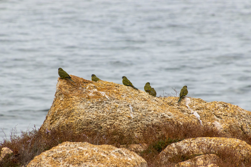
Although we found ourselves closer to Mount Dutton, it was even less visible this morning than it was yesterday from Coffin Bay with a pall of cloud hanging over it. Oh well, the drizzle had eased enough for us to photograph the jetty and the Old Woolshed and, I think, some rock parrots. We made friends with a Border Collie who initially seemed a bit shy, but then brought us a stick to throw. All of us except Cathy obliged by throwing the stick for him!
this time encountering the grader. The is filthy now. A little bit of rain and a freshly graded road will do that!! We continued our journey up the west coast of the Eyre Peninsula with another gloomy stop near Lake Hamilton at the Leo Cummings Monument. Rather sadly Leo was drowned when the crayfish boat ‘Wangaree was wrecked on the cliffs near Kiana in 1959. On this headland we enjoyed views to Point Drummond in the south and to the rugged cliffs of Sheringa to the north. Our second (brief) stop in this area was at the historic Lake Hamilton Eating House. Built around 1857 it was used until the 1880s as a stopping place for coaches and travellers.
With the sun beginning to make an appearance we drove into Locks Well Beach. Locks Well Beach is one of South Australias most reliable locations for catching Australian salmon. The beach can be accessed via a wooden staircase. We decided not to climb all the way down to the beach (283 steps!) opting instead for the viewing platform from which we could see a couple of fishermen trying their luck. They didnt seem to get lucky while we
We arrived in Elliston about lunchtime and found the bakery where we purchased some pies, pasties and sausage rolls and some homemade moments for later on. After eating we found the conveniences where we held up the handyman who was trying to repair the lock on one of the doors. There was someone else there when we arrived and then the four of us before he could get on with his repair work.
Elliston is situated on the shores of the spectacular Waterloo Bay. Matthew Flinders sailed past in 1802 and named Anxious Bay. Waterloo Bay was not named until 1865 on the Golden Jubilee of the Battle of Waterloo. The points at its entrance were then given the names Wellington Point and Wellesley Point.
Elliston is known for its cliff top drives. the Little Bay Clifftop Drive first enjoying fabulous views of Little Bay, Waterloo Bay and Bird Rock. We drove back into town to photograph the mural on the Elliston Community Hall. This mural is purported to be the largest of its type, with artwork adorning every side of the building. Before leaving Elliston the Anxious Bay
Clifftop Drive with views of the Waldegrave Islands, Cape Finniss and Salmon Point. This route has the added attraction of sculptures dotted along the cliffs.
Our final stop for the afternoon was at the Talia Caves. There are two caves: The Tub is a large crater with a 30 metre tunnel that connects it to the sea and The Woolshed is a huge cavern in the granite cliff that can be accessed via a walkway and stairs. Both are spectacular.
With the afternoon drawing to a close we drove straight through to our destination for the night, Sceale Bay. We will be based at the beautiful Sea Change beach house overlooking the bay for the next four nights as we explore the westernmost part of the Eyre Peninsula. With no eating options in town, I made some chow mien for our dinner tonight.